Subarnarekha River: Lifeline, Inspiration, and Source of Identity(2023)
The Subarnarekha River, a timeless ribbon of water, weaves through the eastern landscapes of India, whispering stories of the land and its people. Originating in the Chotanagpur Plateau of Jharkhand, its journey of approximately 395 kilometers touches the states of Jharkhand, West Bengal, and Odisha, leaving its mark in the hearts and histories of the regions it graces.
| Longitude | 85° 8’ to 87° 32’E |
| Latitude | 21° 15’ to 23° 34’ N |
| Length of River (Km) Subernarekha Burhabalang | 395 164 |
| Elevation | 610 m (2,000 ft) |
| Basin size | 18,951 km2 (7,317 sq mi) |
| Discharge | 392 m3/s (13,800 cu ft/s) |
| State | Jharkhand, Odisha, West Bengal |
| Cities | Ranchi, Chandil, Jamshedpur, Ghatshila, Gopiballavpur, Jaleswar |
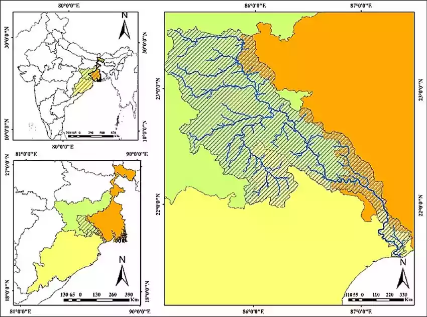
Subarnarekha River Map

The Origin and Route of Subarnarekha River
- One of the longest east-flowing interstate rivers is the Subarnarekha.
- The Subarnarekha basin spans the states of Jharkhand, Odisha, and a minor portion of West Bengal.
- It originates at an elevation of 600 meters near Nagri village in the Ranchi region of Jharkhand.
- The Chota Nagpur Plateau borders it on the northwest, the Brahmani Basin on the southwest, the Burhabalang Basin on the south, and the Bay of Bengal on the southeast.
- Hundru Falls is formed along the Subarnarekha River and falls from a height of 98 meters.
- The Subarnarekha’s major tributaries are the Kharkai, Roro, Kanchi, Harmu Nadi, Damra, Karru, Chinguru, Karakari, Gurma, Garra, Singaduba, Kodia, Dulunga, and Khaijori.
- Sonari (Domuhani), a Jamshedpur area, is where the Kharkai joins the Subarnarekha.
- Getalsud reservoir is located across the Subernarekha, east of Ranchi, and around 50 kilometers from its source.
- The basin is mainly impacted by the South-West monsoon, which begins in June and lasts until October.
- The basin’s yearly rainfall averages roughly 1800 mm. The sub-basin has a tropical climate with hot summers and moderate winters.
- The Subarnarekha multipurpose project called for the construction of two dams, one across the Subarnarekha.
- The majority of the basin is occupied by agricultural land, accounting for 53.76 percent of the total area, and water bodies cover 2.39 percent of the basin.
| Sl.No. | Name of the River/ Tributary | Bank | Length(km) |
|---|---|---|---|
| 1. | Subernarekha | Main Stream | 395 |
| 2. | Kanchi | Right | 76 |
| 3. | Karkari | Right | 110 |
| 4. | Kharkai | Right | 136 |
| 5. | Raru | Right | 52 |
| 6. | Garru | Right | 58 |
| 7. | Dulang | Left | 84 |
Subarnarekha River Tributaries
The Brahmani River, one of the major rivers in eastern India, has several tributaries on its left and right banks.
Tributaries on the Left Bank
1. Dulung River:
Dulung River is a small river that originates in the Simlipal hills of Odisha.
Tributaries on the Right Bank
1. Damra River
It originates in the Simlipal hills of Odisha and joins the Subarnarekha River near Rasgovindpur.
2. Kanchi River
It is a major tributary of the Subarnarekha River and originates in the Chhotanagpur plateau in Jharkhand.
3. Brahmani River
It is a large river that originates in the Kendujhar district of Odisha and joins the Subarnarekha River near Rajghat.
4. Karo River:
It originates from the hills of Jharkhand, the Karo River bestows its blessings upon the Subarnarekha as it joins its course.
5. Kharkai River
It is one of the major tributaries of the Subarnarekha River and originates in Jharkhand
Dams and Projects on the Subarnarekha River
1. Chandil Dam
- The Chandil Dam is located on the Subarnarekha River in Jharkhand, near Chandil town.
- It was built in 1957 for the purpose of irrigation and flood control.
- The dam has a height of 220 feet and a capacity of 20,040,000 cubic meters.
2. Galudih Barrage
- The Galudih Barrage is located in Jharkhand, near Galudih.
- It was built in 1953 for the purpose of irrigation and flood control.
- The barrage has a length of 1,780 feet and a height of 23 feet.
3. Subarnarekha Multipurpose Project
- The Subarnarekha Multipurpose Project is located on the Subarnarekha River near Jamshedpur in Jharkhand.
- It was built in 1996 for the purpose of hydroelectric power generation, irrigation, and flood control.
- The project consists of a dam, a power station, and a canal system.
- The dam has a height of 51 meters and a capacity of 8.88 billion cubic meters.
Conclusion
The Subarnarekha River stands as a testament to the intricate relationship between humans and nature. Its journey through diverse terrains, ecological significance, and cultural resonance make it a symbol of the region’s heritage. As we continue to learn from its past and embrace the need for conservation, the Subarnarekha River remains a flowing legacy that connects us to the essence of eastern India.
FAQs
What is the Subarnarekha River famous for?
Famous for traces of gold particles in its sandy beds.
Where does Subarnarekha River originate from?
It originates at an elevation of 600 meters near Nagri village in the Ranchi region of Jharkhand.
Why is it called Subarnarekha River?
Subarna means gold, and Rekha means a line, also found gold particles in its sandy beds.


